
New Delhi, March 20: Winter forgot to leave. That is really the only way to put it. Three weeks into March, with Holi behind us and summer practically knocking on the door, large parts of India woke up Thursday to cold, wet, angry skies all because of a freak weather system called a Western Disturbance that decided March was too early to quit.
Delhi touched 16 degrees in the afternoon. Not the morning. The afternoon. People in Punjab watched hailstones bounce off their wheat fields. Someone in Shimla posted a video of snow on a road that had been dry and sunny just four days ago. And in Jharkhand, trees fell. Proper, big trees, snapped by winds that had no business being that strong in mid-March.

This is not a passing shower. This is not “oh, the weather has been a bit funny lately.” Something genuinely unusual is happening across the country right now, and it stretches from Kashmir all the way down to Bengaluru, which, frankly, should not even be part of this story.
So What Is Actually Going On
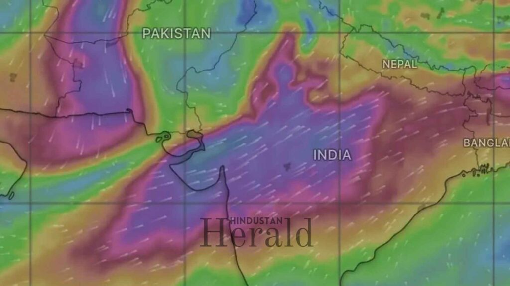
There is a weather system called a Western Disturbance. If you grew up in north India, you have lived through dozens of them without knowing the name. It is basically a large blob of disturbed air that travels from west to east, originating somewhere near the Mediterranean, picking up moisture along the way, and eventually arriving over India carrying rain, snow, and cold. These systems travel with the jet stream and are most active between December and March, which is why they are responsible for most of the winter rain and snowfall across the western Himalayas and the northern plains.
Normally by late March they are winding down. The jet stream shifts, the systems weaken, and we move on to pre-monsoon heat. This one did not get that memo.
What makes this particular disturbance unusual is its shape. Most of these systems come in curved, like a comma. This one has formed as a long, straight trough extending thousands of kilometres, which is uncommon, and that shape is what allows it to intensify cloud formation and hold its strength much longer than usual. Think of it like the difference between a stone thrown into a pond at an angle versus one thrown straight down. The straight drop hits harder and the ripples go further out.
On top of that, this WD has had help. A separate cyclonic circulation sitting over Haryana has been feeding it energy from one side while moisture-laden winds from the Bay of Bengal pushed in from the other. The result is a system that has been intensified from multiple directions at once. Multiple cyclonic circulations combined with this Western Disturbance are driving widespread weather activity including rain, thunderstorms, and dust storms across North, Central, and East India simultaneously.
Where It Has Hit and How Bad
Start up north and work your way down, because this thing has touched nearly every part of the country.
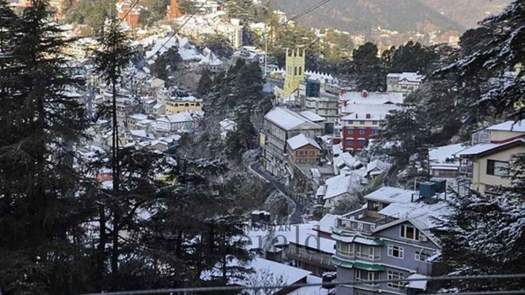
In Jammu and Kashmir, Himachal Pradesh, and Uttarakhand, fresh snowfall has come down at higher altitudes and temperatures have dropped sharply. Hill towns like Lahaul-Spiti, Shimla, Kullu, Kangra, Chamba, and Mandi are all dealing with it. Roads that were fine yesterday are now either snowed under or waterlogged. For people in those areas, this is disruptive but at least familiar. Snow in the hills is not strange. Snow in the hills in late March with no warning is a bit more alarming.

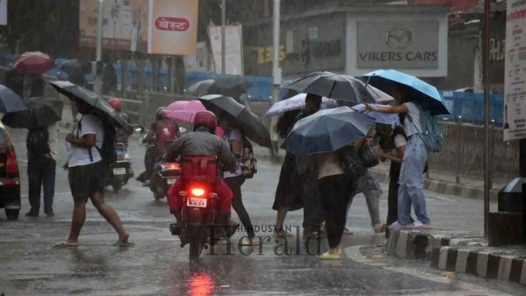
Coming down to the plains, Delhi has seen its maximum temperatures fall by 6 to 7 degrees in a single day, with readings sitting well below normal across the city. Daytime highs are expected to stay between 18 and 24 degrees, which is squarely January weather, not late March weather. Add cloud cover, wind, and rain to that and you have a city that genuinely does not know what season it is.
Punjab, Haryana, western UP, Rajasthan, parts of Madhya Pradesh. All of them are under active alert. The IMD has flagged isolated hailstorm activity across Uttarakhand, Punjab, Haryana, Chandigarh, and West Uttar Pradesh, with gusty winds reaching 40 to 60 kilometres per hour across the plains.
Go east and it gets worse before it gets better. Sub-Himalayan West Bengal and Sikkim are under a very heavy rainfall warning, while Jharkhand is facing thundersqualls with winds gusting up to 70 kilometres per hour.
And then, somehow, Bengaluru. Karnataka and Bengaluru received unexpected hailstorms as part of this same system. A technology city in southern India, dealing with hail in March because a weather system that usually stays in the north has stretched its arms wide enough to reach there too. That is not normal. That is the part of this story that should make people sit up.
The Farmers Taking the Real Hit
Here is the part of this story that matters most and gets discussed least in city-based coverage.
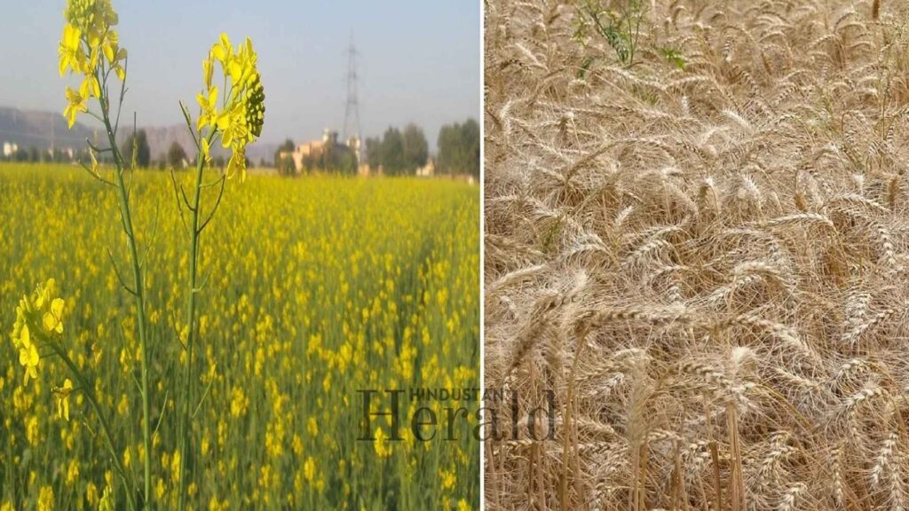
Right now, across Punjab, Haryana, western Uttar Pradesh, and Rajasthan, farmers are in the middle of harvesting wheat and mustard. These are not crops that can be paused. Wheat that is ready to be cut cannot just wait in the field for a week while the weather sorts itself out. When it gets flattened by wind or soaked through by rain at this stage, the damage is not reversible.
Mustard crops in Haryana and Punjab, particularly those ready for harvest, have suffered significant losses from hailstorms and strong winds, with farmers reporting serious concerns about both yield and quality.
What makes it worse is the sequence of events these farmers have already lived through this season. February was abnormally hot. That heat pushed the crops into a kind of premature ripening, which already weakened grain quality before this week arrived. The IMD had warned earlier that conditions could force crops like wheat, oilseeds, and pulses into premature maturity, directly hitting yields and quality. So farmers entered harvest season with crops that were already compromised. Now, just as they are trying to salvage what they can, hailstones arrive.
Winds in the range of 40 to 50 kilometres per hour are considered particularly damaging at the ripening and harvesting stage, causing crop flattening and waterlogging that further destroys ready-to-harvest wheat.
The IMD has advised farmers to drain excess water from fields to prevent root rot. That is technically correct advice. It does not help the farmer in Karnal who is standing in a field watching stalks bent flat to the ground, wondering how much of the crop can still be saved and whether the government compensation if it comes will arrive before the debt collector does. These things move slowly. Damage assessments, insurance claims, state government announcements. Farmers are expected to survive the gap on hope and borrowed money.
This has happened before and it will happen again. The difference now is it is happening more often and at stranger times.
Why This Keeps Happening More
This is the part where it is tempting to shrug and say “weather is unpredictable.” But that is not quite honest anymore.
IMD’s own Director General has publicly noted that while around five to seven Western Disturbances form every month, many of them are now weaker or pass quickly without much impact, with overall WD-driven rainfall actually declining over time. So you have fewer of them doing real work across the season, but the ones that do arrive are arriving harder and at unexpected times.
Research spanning five decades from a university in Himachal Pradesh found that the largest number of Western Disturbance events actually cluster between March and May, not in the core winter months most people associate with them. That finding flips the common assumption. These systems are not just a December-to-February thing. They are a year-round threat that we are only beginning to account for properly.
Scientists link this shifting behaviour to global warming, pointing out that jet streams are meandering further south than they historically did, and that Arctic warming driven by melting sea ice is disturbing the large-scale atmospheric patterns that govern how these systems form and travel. Mongabay
None of this is abstract. When the jet stream wanders, a weather system meant to stay in the north reaches Bengaluru. When Arctic warming destabilises atmospheric patterns, a late-March disturbance hits with January force. The long-run science and the short-run human cost are the same story told from different distances.
What Happens Next
Delhi and the northwest plains should begin to see clearing skies by Thursday evening, with temperatures gradually recovering through the weekend. The system is moving east, and by Friday, its main force will have shifted to Bihar and West Bengal, where communities are bracing for the tail end.

But the relief will not last long. Another Western Disturbance is already forming and is expected to reach northwest India around March 22. And beyond that, forecasters are tracking continued thunderstorm activity and widespread rainfall through the week of March 26 to April 1 across the Himalayan region and northeast India.
Three systems in ten days. For farmers who need a clean, dry fortnight to bring in their harvest, that is not a forecast, it is a verdict.
March 2026 opened with a heatwave and is closing with hailstones. Somewhere between those two extremes, millions of people across north and central India are trying to make sense of weather that simply does not follow the old rules anymore. The farmers are doing it from their ruined fields. The meteorologists are doing it from their data. City people are doing it from their windows, slightly confused, reaching for a jacket they thought they would not need until November.
What they are all experiencing, whether they have a name for it or not, is climate instability made personal. Cold in March. Hail during harvest. Snow when it should be spring.
This is what it looks like when the weather forgets what month it is.
Stay ahead with Hindustan Herald — bringing you trusted news, sharp analysis, and stories that matter across Politics, Business, Technology, Sports, Entertainment, Lifestyle, and more.
Connect with us on Facebook, Instagram, X (Twitter), LinkedIn, YouTube, and join our Telegram community @hindustanherald for real-time updates.

- Arun Upadhayay

- Arun Upadhayay
- Arun Upadhayay
- Arun Upadhayay